Have you ever asked yourself about Chile’s long and narrow shape? I have and found out that there are two main reasons for this: Colonial Expansions and Natural Boundaries. I will elaborate a bit on both of these aspects.
Natural boundaries – Andes
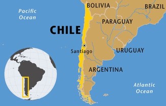
Let’s start with some background on Chile’s geography. Chile is located between the Andes mountains (east) and the Pacific Ocean (west). It’s average width along it’s long and narrow lands is 109 miles (that’s about the width of Puerto Rico). Despite its narrow shape, Chile is home to the highest mountains of the western hemisphere, the Andes. This mountain range runs along the border of Argentina and occupies close half of its Chile’s width.
Colonial expansion
Colonial expansion is the other reason that has given Chile its current shape. In the 16th century, Spanish colonists moved from Peru to Chile in search of gold. They colonized most of the coastal territory of Chile but got discouraged by the Andes mountains to continue expanding towards Chile’s eastern territories. In 1818, three centuries from this, Chile liberates itself from the Spaniards and starts to seek its own territories to conquer.
Two main wars allowed Chile to expand its northern and southern borders: the war of the Pacific, where they fought Bolivia and Peru for expansion, and the war against the Mapuche and indigenous tribe who resided below the south border of Chile. Chile won both of these wars and gained valuable territory in each which has allowed them to become a successful South American country.
References
http://www.lonelyplanet.com/chile/history
http://countrystudies.us/chile/5.htm
http://www.slate.com/articles/news_and_politics/explainer/2010/03/why_is_chile_so_long_and_skinny.html
http://kids.nationalgeographic.com/content/dam/kids/photos/Countries/A-G/chile-map.jpg
Natural boundaries – Andes
Let’s start with some background on Chile’s geography. Chile is located between the Andes mountains (east) and the Pacific Ocean (west). It’s average width along it’s long and narrow lands is 109 miles (that’s about the width of Puerto Rico). Despite its narrow shape, Chile is home to the highest mountains of the western hemisphere, the Andes. This mountain range runs along the border of Argentina and occupies close half of its Chile’s width.
Colonial expansion
Colonial expansion is the other reason that has given Chile its current shape. In the 16th century, Spanish colonists moved from Peru to Chile in search of gold. They colonized most of the coastal territory of Chile but got discouraged by the Andes mountains to continue expanding towards Chile’s eastern territories. In 1818, three centuries from this, Chile liberates itself from the Spaniards and starts to seek its own territories to conquer.
Two main wars allowed Chile to expand its northern and southern borders: the war of the Pacific, where they fought Bolivia and Peru for expansion, and the war against the Mapuche and indigenous tribe who resided below the south border of Chile. Chile won both of these wars and gained valuable territory in each which has allowed them to become a successful South American country.
References
http://www.lonelyplanet.com/chile/history
http://countrystudies.us/chile/5.htm
http://www.slate.com/articles/news_and_politics/explainer/2010/03/why_is_chile_so_long_and_skinny.html
http://kids.nationalgeographic.com/content/dam/kids/photos/Countries/A-G/chile-map.jpg
